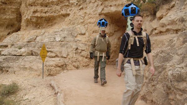
In Google’s continuing effort to create the most comprehensive and accurate worldwide maps possible, the gigantic search engine this week went beyond the streets and skies, taking cameras down into the popular American tourist site, the Grand Canyon.
Google launched the Trekker, a sophisticated wearable backpack with a high-tech camera on top, sending three of the devices into the Grand Canyon, the first step towards mapping and showcasing remote destinations around the world accessible only by foot.
"Any of these sort of iconic, cultural, historical locations that are not accessible by road is where we want to go," said Ryan Falor, product manager at Google, according to the Associated Press.
Falor and two teams from Google hiked into the Grand Canyon’s South Rim, bringing them 4,500 feet (1,372 meters) into the landmark’s immense ravine. The camera system is capturing 360-degree pictures, which will be stitched together to create the panoramic images found in Google Maps.
The Trekker backpacks weigh 40 pounds (18 kilograms) and are equipped with a set of 15-specially designed camera lenses that are arranged into a metal contraption that looks like a soccer ball, capturing images every 2.5 seconds.
On top of the ball, there are also two GPS receivers and sensors that record temperature, vibrations and the device’s location as it is hiked through the Grand Canyon’s many steep and rugged switchbacks.
“When we were designing Trekker, we really knew we wanted to take it to these rugged, remote locations,” said Falor. “We worked really hard to make sure it was waterproof and could handle heat and cold and all kinds of abuse on the trail.”
Google’s journey into the Grand Canyon comes after Apple decided to drop Google Maps from its mobile operating systems and use its own mapping system that has suffered from glitches since it launched last month, providing bad directions and mislabeling locations for users.
The search giant announced the Trekker back in June, but the trip into the Grand Canyon is the first time the device has been used to collect pictures. It could be months before Google will release the images to the public, Falor said.
Trekker’s pictures will be used in the Google Maps Street View feature, which lets viewers explore natural wonders, landmarks and locations around the world through 360-degree street-level imagery with the click of a button.
In the past, panoramic views have been collected by Google’s Street View cars, tricycles and snowmobiles that have traveled more than 5 million miles (8 million kilometers) around the world, capturing scenery in 3,000 cities and 43 countries.
Through the launch of Trekker, people will be able to marvel and admire the beauty of the Grand Canyon from the comfort of their homes, which could help some plan their future hikes into the national park or view a part of the world that they may not be able to travel to in their lifetime.
Google is planning more Trekker trips in the future, including a possible visit to Mount Everest.


