Militants of the Islamic State terrorist organization have looted and destroyed nearly 750 cultural heritage sited in Syria since the beginning of the conflict in the country, Syria’s Deputy Culture Minister Ali Al-Qayyim said. UNESCO formed special "response forces" which will take part in an international campaign to restore ancient monuments damaged during combat actions in Arab countries.
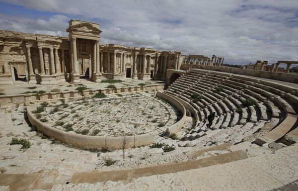
Palmyra city is one of the most prosperous cities of the Late Antiquity. It is located in an oasis 240 kilometers northeast of Damascus and over 306 kilometers from the Euphrates River. The area of the city boasts ruins of structures which are among the most outstanding examples of the Ancient Roman architecture. They were listed by UNESCO as World Heritage sites. On May 14, Palmyra was seized by ISIL militants. They took over the historic part of the town where temple complexes and other architecture monuments from the period of Roman rule are located.
Above: A partial view of the theatre at the ancient oasis city of Palmyra. The photo was taken on March 14, 2014.
Above: A partial view of the theatre at the ancient oasis city of Palmyra. The photo was taken on March 14, 2014.
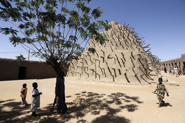
The Tomb of Askia, in Gao, Mali, is believed to be the burial place of Askia Mohammad I, one of the medieval Songhai Empire’s most prolific emperors. He was the first ruler in Sahel to declare himself a Muslim. At 17 meters in height the Toms of Askia is the largest pre-colonial architectural monument in the region. It is the first example of an Islamic architectural style that later spread throughout the region. In 2012 the Tomb of Askia was declared a UNESCO World Heritage Site in Danger due to fears it could be destroyed by militants from the National Movement for the Liberation of Azawad.
Above: Children play beside the Tomb of the Askia on February 15, 2013 in Gao, northern Mali.
Above: Children play beside the Tomb of the Askia on February 15, 2013 in Gao, northern Mali.
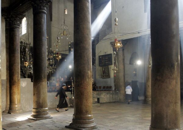
The Church of the Nativity is a basilica located in Bethlehem, Palestine. It is traditionally considered to be built over the cave that marks the birthplace of Jesus Christ. Along with the Church of the Holy Sepulchre, it is one of the two main Christian shrines in the Holy Land. In 2012, the church complex became the first Palestinian site to be listed as a World Heritage Site. It has also been placed on the List of World Heritage in Danger as it is suffering from damages due to water leaks.
Above: Christian nuns and worshippers move through the Church of the Nativity, in the West Bank town of Bethlehem, 25 November 2007.
Above: Christian nuns and worshippers move through the Church of the Nativity, in the West Bank town of Bethlehem, 25 November 2007.
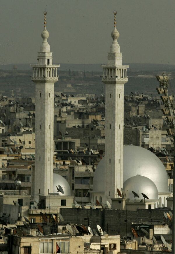
The Great Mosque of Aleppo is the largest and the oldest mosque in the Syrian town of Aleppo. It is located in al-Jalloum district of the Ancient City of Aleppo, a World Heritage Site. The mosque is purportedly home to the remains of Zechariah, the father of John the Baptist. It was built in the beginning of the 8th century. However, the current building dates back to the 11th through 14th centuries. The single minaret was built in 1090. In October 2012, during the Syrian war, government forces stormed the mosque where armed opposition forces had locked them out. The building was shelled and caught fire. In late-February 2013, anti-government forces blew up the southern wall of the mosque. In late-April 2013, the minaret was demolished during fighting between rebels and regime forces.
Above: A picture taken 17 March 2006 shows a general view of the historic Syrian city of Aleppo with the Great Mosque in the center.
Above: A picture taken 17 March 2006 shows a general view of the historic Syrian city of Aleppo with the Great Mosque in the center.
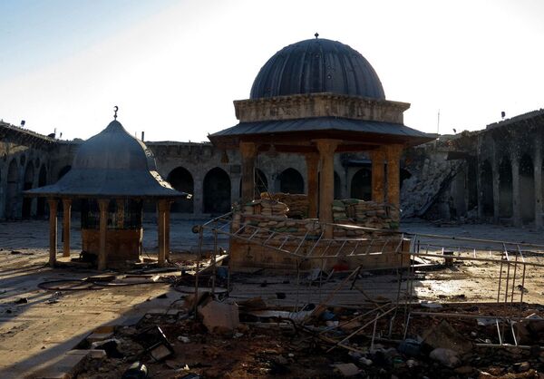
The Umayyad Mosque, also known as the Great Mosque of Damascus, is one of the largest and oldest mosques in the world. It is located at one the most sacred sites in the old city of Damascus. It is considered by some Muslims to be the fourth-holiest place in Islam. After the Arab conquest of Damascus in 634, the mosque was built on the site of a Christian basilica dedicated to John the Baptist (Yahya), honored as a prophet by Christians and Muslims alike. A legend dating to the 6th century holds that the building contains the head of John the Baptist. The mosque was seriously damaged during the Syrian war.
Above: A picture taken on April 25, 2013 shows the rubble of the minaret of Aleppo's ancient Umayyad Mosque.
Above: A picture taken on April 25, 2013 shows the rubble of the minaret of Aleppo's ancient Umayyad Mosque.
6/13
© AP Photo / Stringer
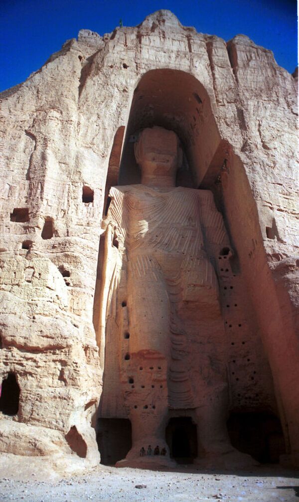
The Buddhas of Bamiyan were the two 6th-century monumental statues of standing Buddha carved in a cliff in the Bamyam valley in central Afghanistan. The larger Buddha measured 53 meters tall, and the smaller – 35 meters. The statues were built in 507 AD (smaller) and 554 AD (larger). They represented the classic style of Gandhara art. In 2001, the statues were ruined by Taliban militants who considered them as pagan idols. In 2011, UNESCO announced it would not reconstruct the Buddhas due to lack of funding. UNESCO also claimed that the restored statue would contain more than 50 percent of new material and would lose their historical value.
Above: This May 15, 1999, photo shows the world's tallest statue of Buddha measuring 53 meters (175 feet) in Bamiyan, 125 kilometers (90 miles) west of Kabul in Afghanistan.
Above: This May 15, 1999, photo shows the world's tallest statue of Buddha measuring 53 meters (175 feet) in Bamiyan, 125 kilometers (90 miles) west of Kabul in Afghanistan.
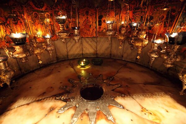
The Cave of the Nativity is one the greatest Christian shrines. It is a cave which is traditionally believed to be the birthplace of Jesus Christ. It is located under the ambo of the Church of the Nativity in Bethlehem, Palestine. The first written accounts of the cave are dated back to 150. The underground temple has been there since the time of Saint Helena. The shrine belongs to the the Orthodox Church of Jerusalem.
Above: A view of the Cave of the Nativity, Bethlehem.
Above: A view of the Cave of the Nativity, Bethlehem.
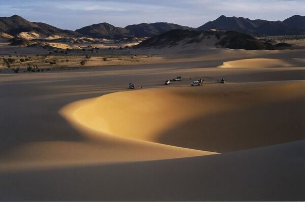
The Ténéré is a desert region in the south central Sahara. It comprises a vast plain of sand stretching from northeastern Niger into western Chad, occupying an area of over 400,000 square kilometers. The Aïr and Ténéré UNESCO World Heritage Site was established in 1991, and marked as endangered 1992. The entire reserve covers 77,360 square kilometers, which made it the second largest nature reserve in Africa, and the fourth largest in the world.
Above: A view of the The Aïr and Ténéré National Nature Reserve.
Above: A view of the The Aïr and Ténéré National Nature Reserve.
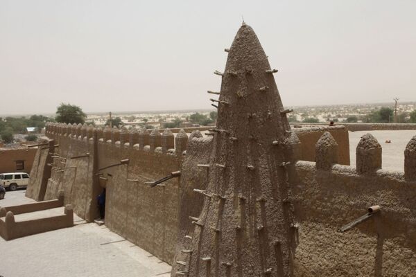
The Djinguereber Mosque (Masjid) in Timbuktu, Mali is a famous learning center of Mali built in 1327. Djinguereber is one of four madrassas composing the University of Timbuktu. It was inscribed on the list of UNESCO World Heritage Sites in 1988, and in 1990 was considered to be in danger due to sand encroachment. In July 2012, Islamists of the Ansar Dine (Defenders of Faith) destroyed two tombs at the Djingareyber mosque. Declaring the ancient Muslim shrines "haram", or forbidden in Islam, Ansar Dine set about destroying seven of Timbuktu's 16 mausoleums of ancient Muslim saints.
Above: A picture taken on April 8, 2015 shows the Djinguereber Mosque in Timbuktu, Mali.
Above: A picture taken on April 8, 2015 shows the Djinguereber Mosque in Timbuktu, Mali.
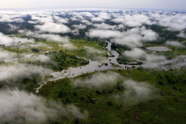
Garamba National Park is located in the north-east of the Democratic Republic of Congo. It is one of the oldest Africa’s national parks. It is famous for being the habitat for the world's last known wild population of the northern white rhinoceros, a rare subspecies of the white rhinoceros. In 1960 its population numbered 1,000 individuals. However, by 1980 after a 20-year-long war in Congo the population dropped to 12. The park was designated a UNESCO World Heritage Site in 1980. Due to poaching of the rhinos within the park, it was added to the list of World Heritage in Danger in 1996.
Above: A view of Garamba National Park in Congo.
Above: A view of Garamba National Park in Congo.
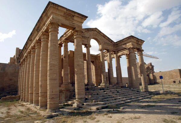
Hatra was an ancient city in the Parthian Empire. Now its ruins are located in in the Ninawa Governorate in Northern Iraq. Hatra was probably built in the 3rd or 2nd century BC by the Seleucid Empire. The city reached the zenith of its prosperity during the 2nd century BC due to being situated at the crossroads of important trade routes.
Hatra embraced Hellenic and Ancient Roman architecture along with Arab décor style. In 1985, Hatra was declared a UNESCO World Heritage Site. On March 7, 2015, the ruins of Hatra were demolished by ISIL militants.
Above: Picture shows the Hellenistic Temple of Mrn amid the remains of the ancient city of, April 21, 2003.
12/13
© AP Photo / Visar Kryeziu
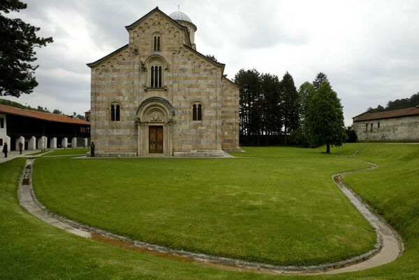
Visoki Decani is the main Serbian Orthodox monastery in Kosovo. It is situated 12 kilometers south of the city of Pec, in western Kosovo. The main cathedral of the monastery is the largest medieval temple in Balkans. It boasts the largest preserved collection of Byzantine wall painting, featuring over 1,000 compositions and several thousand portraits. In 2006 the monastery was declared a UNESCO World Heritage Site in Danger due to possible attacks by militants from the Kosovo Liberation Army.
Above: A view of the Serb Orthodox Monastery of Visoki Decani in western Kosovo. The photo was taken on May 11, 2006.
Above: A view of the Serb Orthodox Monastery of Visoki Decani in western Kosovo. The photo was taken on May 11, 2006.
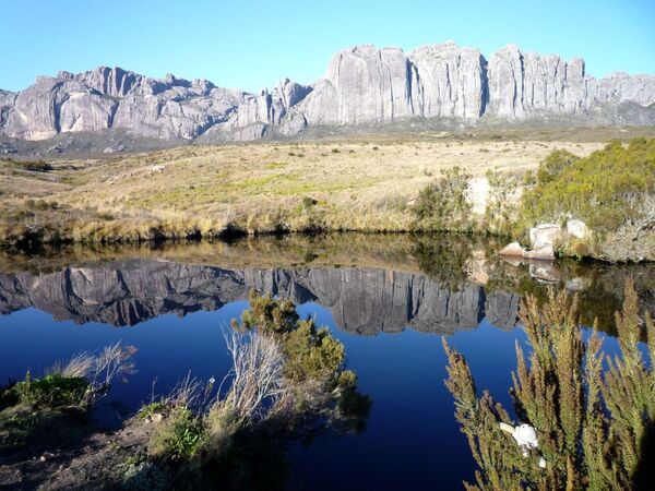
The Rainforests of the Atsinanana is relict forests located at the eastern coast of the Madagascar Island. Its unique climate and geographic position created here the habitat for many species of plants and animals. Andringitra National Park is National Park in the Haute Matsiatra Region of Madagascar, 47 km (29 mi) south of Ambalavao. Approximately 140 km (87 mi) of the Tropic of Capricorn crosses the park. It was inscribed in the World Heritage Site in 2007 as part of the Rainforests of the Atsinanana. In 2010, the rainforests was declared a UNESCO World Heritage Site in Danger.
Above: A view of Andringitra National Park, Madagascar.
Above: A view of Andringitra National Park, Madagascar.

