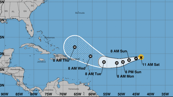
As of Friday, September 1, Hurricane Irma had rapidly escalated from a disorganized tropical storm to a powerful Category 3 hurricane, packing winds up to 120 mph, according to the NOAA National Hurricane Center (NHC).
Irma, still in the Atlantic Ocean, is tracking to reach islands in the Caribbean Sea within the next several days, and, based on new data, it's landing point on US soil — from Louisiana to Florida or back out to sea — still remains anyone's guess.
Irma follows last week's Hurricane Harvey which landed in Texas and broke all records for rainfall and flood damage in the region. The city of Houston and its surrounding metropolitan area have been decimated, as almost all services came to a halt and tens of thousands are still without power a week after the storm struck.
Irma, which has since rebuilt its eyewall, became a Category 2 storm on Saturday with winds still raging at some 110 mph due to cooler central ocean waters, but is expected to accelerate its size and power when it reaches the warmth of the Caribbean Sea.
The NHC announced on early Saturday morning that Irma "continues to fluctuate in strength but remains a powerful hurricane," although its movements over the next several days are next to impossible to predict, cited by CBSnews.com.
The storm, currently some 1,200 miles east of Puerto Rico, is traveling west at about 15 mph.
An NHC spokesperson stated that Irma would "remain a powerful hurricane into early next week."
As of Saturday no coastal watches or hurricane warnings have been posted in the region.


