One of the magnificent and historically important sites that was destroyed is the Temple of Baalshamin in Palmyra, Syria.
Palmyra used to serve as the capital of the Palmyrene Empire and was one of the richest cities of the Roman Empire. The ancient ruins and monuments of Palmyra, a UNESCO World Heritage site, lost several important artifacts and structures at the hands of the Daesh* terrorist group in 2015.
*Daesh is a terrorist group outlawed in Russia and many other countries.
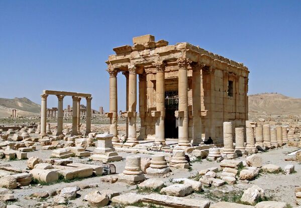
CC BY-SA 3.0 / Bernard Gagnon / Temple of Baal-Shamin in Palmyra, SyriaPalmyra was the capital of the Palmyrene Empire and one of the richest cities of the Roman Empire. The ancient ruins and monuments of Palmyra, a UNESCO World Heritage site, lost several important artefacts at the hands of terrorists in 2015. The Temple of Bel, Temple of Baalshamin, Arch of Triumph and columns in the Valley of the Tombs were destroyed by terrorists.
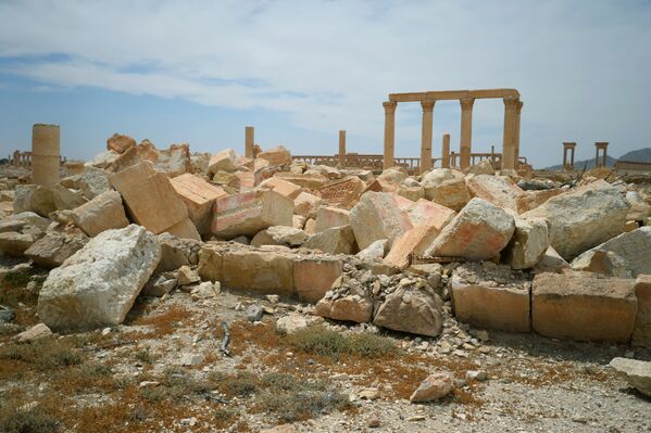
Palmyra was the capital of the Palmyrene Empire and one of the richest cities of the Roman Empire. The ancient ruins and monuments of Palmyra, a UNESCO World Heritage site, lost several important artefacts at the hands of terrorists in 2015. The Temple of Bel, Temple of Baalshamin, Arch of Triumph and columns in the Valley of the Tombs were destroyed by terrorists.
© Sputnik / Mikhail Voskresenskiy / Go to the mediabankPalmyra was the capital of the Palmyrene Empire and one of the richest cities of the Roman Empire. The ancient ruins and monuments of Palmyra, a UNESCO World Heritage site, lost several important artefacts at the hands of terrorists in 2015. The Temple of Bel, Temple of Baalshamin, Arch of Triumph and columns in the Valley of the Tombs were destroyed by terrorists.
Palmyra was the capital of the Palmyrene Empire and one of the richest cities of the Roman Empire. The ancient ruins and monuments of Palmyra, a UNESCO World Heritage site, lost several important artefacts at the hands of terrorists in 2015. The Temple of Bel, Temple of Baalshamin, Arch of Triumph and columns in the Valley of the Tombs were destroyed by terrorists.
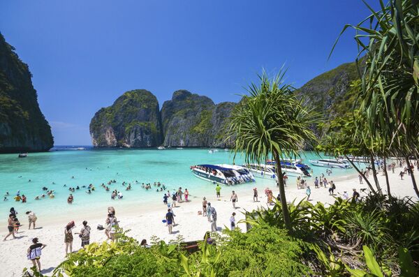
© AP Photo / Rajavi OmaneeTourists used to enjoy the popular Maya bay on Phi Phi island, Krabi Province. However, authorities ordered the temporary closing of the beach made famous by the Leonardo DiCaprio movie "The Beach" to halt environmental damage caused by excessive tourist activity.
3/15
© AP Photo / Rajavi Omanee
Tourists used to enjoy the popular Maya bay on Phi Phi island, Krabi Province. However, authorities ordered the temporary closing of the beach made famous by the Leonardo DiCaprio movie "The Beach" to halt environmental damage caused by excessive tourist activity.
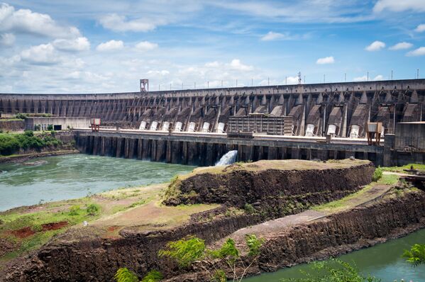
CC BY 2.0 / Deni Williams / Usina Hidroelétrica Itaipu Binacional / Itaipu DamThe Itaipu Dam was a hydroelectric dam on the Paraná River located on the border between Brazil and Paraguay.
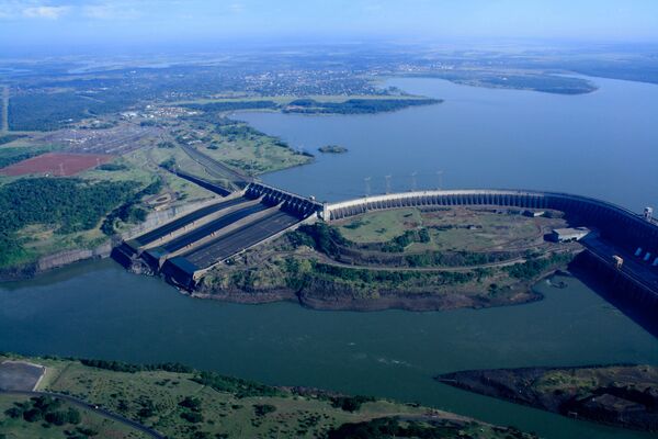
The Itaipu Dam was a hydroelectric dam on the Paraná River located on the border between Brazil and Paraguay.
CC BY 2.0 / International Hydropower Association / IHA 2011 World Congress - SightseeingThe Itaipu Dam was a hydroelectric dam on the Paraná River located on the border between Brazil and Paraguay.
The Itaipu Dam was a hydroelectric dam on the Paraná River located on the border between Brazil and Paraguay.
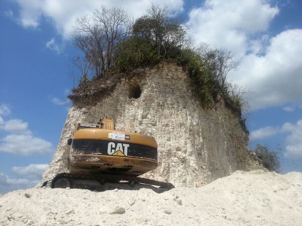
© AFP 2023 / Jules VasquezA construction company owned by a local politician demolished this 2,300-year-old Mayan temple in northern Belize to use the rubble as gravel for road repair work in 2013. The ancient 30-metre-high pyramid, which was reduced to a small mound of debris, was part of the Noh Mul ceremonial centre located 80 kilometres (50 miles) northwest of Belize City near the border with Mexico.
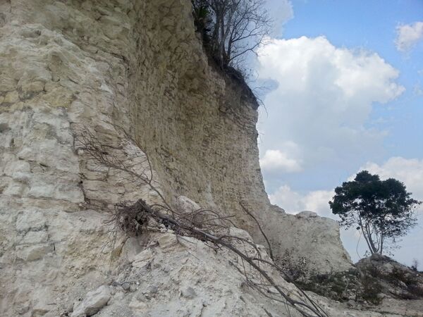
A construction company owned by a local politician demolished this 2,300-year-old Mayan temple in northern Belize to use the rubble as gravel for road repair work in 2013. The ancient 30-metre-high pyramid, which was reduced to a small mound of debris, was part of the Noh Mul ceremonial centre located 80 kilometres (50 miles) northwest of Belize City near the border with Mexico.
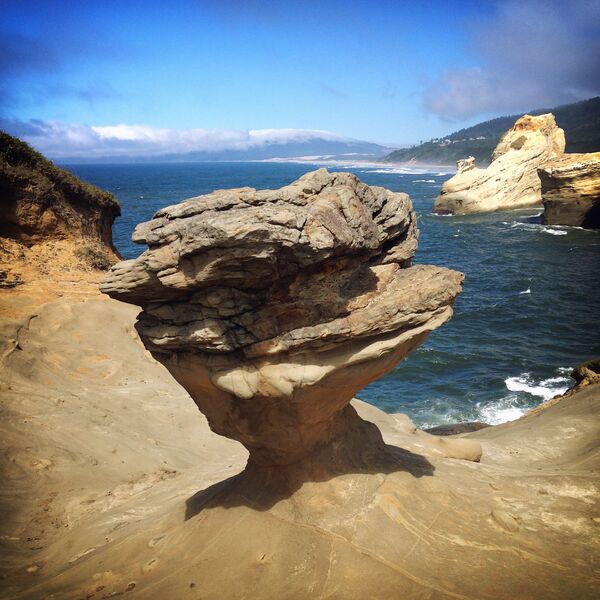
CC BY-SA 4.0 / Steven Pavlov / Duckbill (cropped image)Duckbill (rock formation at Cape Kiwanda State Natural Area) before 29 August 2016.
Duckbill (rock formation at Cape Kiwanda State Natural Area) before 29 August 2016.
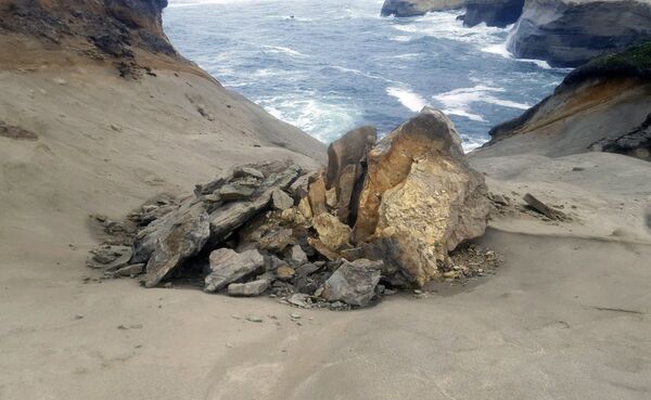
© AP Photo / State of Oregon, Oregon Parks and Recreation DepartmentThis undated photo provided by the State of Oregon, Oregon Parks and Recreation Department shows a natural rock formation. The sandstone pedestal was roughly 7 feet to 10 feet across and located in a fenced off section of the park. Oregon State Parks officials originally said they did not think the damage was caused by humans but cellphone video captured a group of people knocking over the popular sandstone rock formation known as the "Duckbill" on the Oregon beach.
9/15
© AP Photo / State of Oregon, Oregon Parks and Recreation Department
This undated photo provided by the State of Oregon, Oregon Parks and Recreation Department shows a natural rock formation. The sandstone pedestal was roughly 7 feet to 10 feet across and located in a fenced off section of the park. Oregon State Parks officials originally said they did not think the damage was caused by humans but cellphone video captured a group of people knocking over the popular sandstone rock formation known as the "Duckbill" on the Oregon beach.
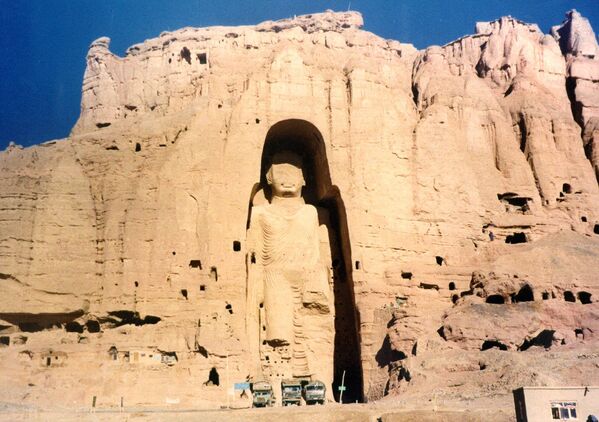
© AP Photo / Zaheeruddin AbdullahThe 53-metre-tall, 2000-year-old Buddha statue located in Bamyan, about 150 kilometres (90 miles) west of the Afghan capital Kabul, is shown in 1997 photo. Afghanistan's hardline Taliban rulers ordered its destruction.
10/15
© AP Photo / Zaheeruddin Abdullah
The 53-metre-tall, 2000-year-old Buddha statue located in Bamyan, about 150 kilometres (90 miles) west of the Afghan capital Kabul, is shown in 1997 photo. Afghanistan's hardline Taliban rulers ordered its destruction.
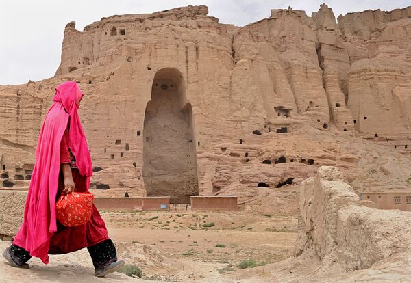
© AFP 2023 / Shah MaraiA Hazara Afghan woman walks past the ruins of ancient Buddha statues that once stood in the city of Bamiyan. The town was home to two nearly 2,000-year-old Buddha statues before they were destroyed by the Taliban, months before their regime was toppled in a US-led invasion in late 2001.
A Hazara Afghan woman walks past the ruins of ancient Buddha statues that once stood in the city of Bamiyan. The town was home to two nearly 2,000-year-old Buddha statues before they were destroyed by the Taliban, months before their regime was toppled in a US-led invasion in late 2001.
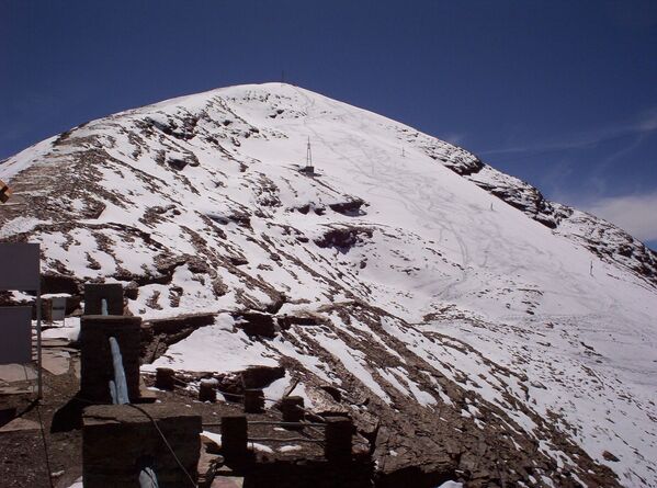
CC BY-SA 3.0 / Thomas Wilken / Chacaltaya 2Bolivia's Chacaltaya Glacier in 2005. The renown Chacalyaya's ski run, at 5,300 metres (18,500 feet) above sea level, no longer exists because of global warming and all that remains of its past splendour is a rocky hilltop.
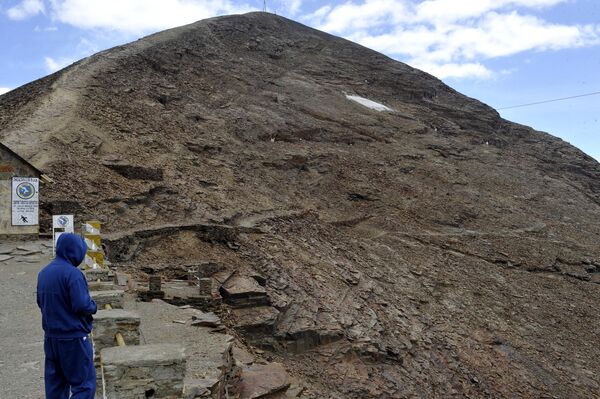
Bolivia's Chacaltaya Glacier in 2005. The renown Chacalyaya's ski run, at 5,300 metres (18,500 feet) above sea level, no longer exists because of global warming and all that remains of its past splendour is a rocky hilltop.
© AFP 2023 / Aizar RaldesThe renown Chacalyaya's ski run, at 5,300 meter (18,500 feet) above sea level, is now dead because of the global warming and all that remains of its past splendour is a rocky hilltop.
The renown Chacalyaya's ski run, at 5,300 meter (18,500 feet) above sea level, is now dead because of the global warming and all that remains of its past splendour is a rocky hilltop.
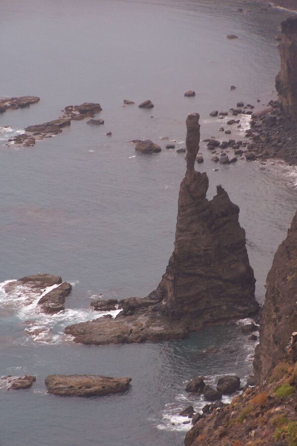
CC BY-SA 3.0 / Mjk1980 / Dedo de Dios am 30.09.2005The rocky monument El Dedo de Dios (God's finger in Spanish) after a storm; it used to be located off the northern part of Gran Canaria.
The rocky monument El Dedo de Dios (God's finger in Spanish) after a storm; it used to be located off the northern part of Gran Canaria.
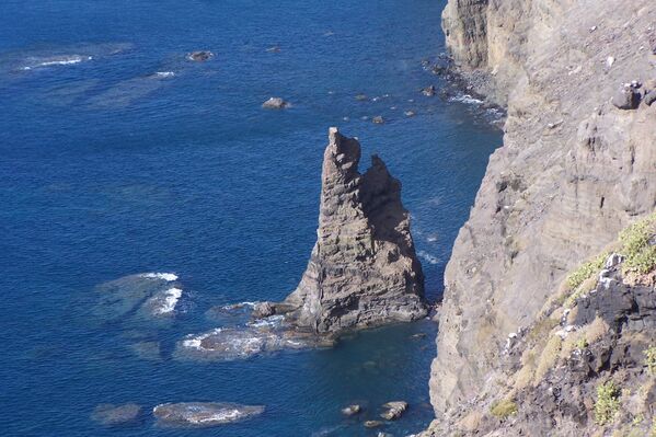
CC BY-SA 3.0 / Mjk1980 / Dedo de Dios am 05.12.2005The rocky monument El Dedo de Dios (God's finger in Spanish) after a storm; it used to be located off the northern part of Gran Canaria.
The rocky monument El Dedo de Dios (God's finger in Spanish) after a storm; it used to be located off the northern part of Gran Canaria.