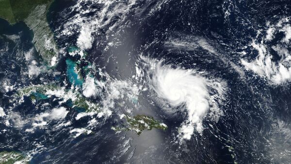
A group of thunderstorms labeled a “tropical disturbance” by the National Weather Service poses a danger of becoming a more serious and powerful storm in the coming days.
Invest 95L was marked by the National Hurricane Center (NHC) as “Potential Tropical Cyclone Nine” in a 5 p.m. Thursday advisory that warned the storm cluster “is expected to become a tropical storm and bring tropical storm force winds to portions of the northwest Bahamas within 36 hours,” a part of the island nation that was heavily damaged just days ago by the powerful Hurricane Dorian.
Here are the 5pm EDT Key Messages on Potential Tropical Cyclone #Nine. Uncertainty in the forecast is higher than usual, however tropical-storm-force winds and heavy rainfall are expected in portions of the northwest Bahamas on Friday and Saturday. https://t.co/tW4KeGdBFb pic.twitter.com/7RZeWLKL9h
— National Hurricane Center (@NHC_Atlantic) September 12, 2019
If the cluster reaches tropical storm strength, it would be named Humberto and would bring heavy rain and strong winds to the Bahamas and parts of eastern Florida. However, the NHC noted the storm poses little danger of storm surges to the Bahamas.
The northwestern Bahamian islands of Grand Bahama and Great Abaco were utterly devastated by Dorian, which passed over them at a crawling pace, unleashing 185 mph winds and a devastating storm surge that swallowed much of the islands in seawater.
“The storm is not expected to become a hurricane, especially since there is lots of uncertainty in the forecast,” Tampa-based Bay News 9 reported Thursday evening. “The first potential track puts all of Central Florida in its cone of uncertainty.”
In fact, the storm’s projected path has changed significantly over the past few days and might change further still. Some computer models still have it passing across Florida and into the Gulf of Mexico, but others have it hooking a hard right and going up the US East Coast, following much the same track Dorian did.
And yes, one of the models does pass through Alabama.
BREAKING: We now have Potential Tropical Cyclone Nine near the Bahamas. All interests in the northwestern Bahamas, Florida and southeastern U.S. should pay close attention to this forecast. pic.twitter.com/iMcOXdfMFR
— The Weather Channel (@weatherchannel) September 12, 2019
The NHC is expected to send an Air Force Reserve Hurricane Hunter aircraft on a mission above the storm late Thursday, to take more accurate wind and air pressure measurements, which will help give a better gauge of the storm’s power and potential.
While Dorian loitered for more than 24 hours over some of the same parts of the ocean that 95L will soon traverse, draining so much of the sea’s hot water as to weaken the new storm significantly, the waters there are “still plenty warm for development,” meteorological blog Category 6 noted Thursday afternoon, observing the sea temperature in the western Bahamas was a balmy 84 degrees Fahrenheit. Tropical storms become stronger by passing over warm, wet updrafts rising from the sea and weaken over cooler waters or land, both of which disrupt the process of storm formation.
The Weather Channel noted that if the storm coalesces and forms a coherent center sooner rather than later, the models have it taking the easterly track as a stronger storm, but if it forms later, it will be weaker and is more likely to continue westward toward the Gulf. Regardless, the storm is not expected to reach hurricane strength, which happens when it has sustained 75 mph winds.


