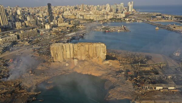
Researchers from NASA's Advanced Rapid Imaging and Analysis (ARIA) team have collaborated with their colleagues from the Earth Observatory of Singapore to use satellite data to evaluate the extent of the damage wrought by massive explosion that devastated the capital of Lebanon on 4 August.
According to a statement posted on NASA's official website, "synthetic aperture radar data from space shows ground surface changes from before and after a major event like an earthquake", and in this particular case, "it is being used to show the devastating result of an explosion".
Satellite-derived synthetic aperture radar data mapping the likely extent of damage from the massive Aug. 4 explosion in Beirut.
— Waël Atallah (@wael_atallah) August 8, 2020
By: NASA's Advanced Rapid Imaging and Analysis (ARIA) team, in collaboration with the Earth Observatory of Singapore. pic.twitter.com/h3HS0WsmeS
#NASA’s ARIA team in collab. with the EOS used satellite data to map the extent of damage following a massive explosion in Beirut
— Dr.Sabine kik (@KikSabine) August 8, 2020
Dark red pixels represent the most severe damage areas
Orange=moderately damaged
Yellow=sustained somewhat less damage Each colored pixel=area of 30m pic.twitter.com/wqkGi2OSWC
In the map in question, each colored pixel represents an "area of 30 meters", with red pixels marking areas that sustained the "most severe damage", orange shows "moderately damaged" areas, while "areas in yellow are likely to have sustained somewhat less damage".
The map "contains modified Copernicus Sentinel data processed by ESA (European Space Agency) and analyzed by ARIA team scientists at NASA JPL, Caltech, and Earth Observatory of Singapore", the US space agency adds, noting that such maps can "help identify badly damaged areas where people may need assistance".
On 4 August, a powerful explosion virtually obliterated Beirut's port and damaged numerous buildings in the city, claiming the lives of more than 150 people and injuring some 5,000.
According to the authorities, the explosion was caused by 2,750 tonnes of confiscated ammonium nitrate stored for years in a port warehouse.


