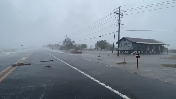
According to the US National Weather Service, Zeta has central sustained winds topping 110 miles per hour, as the storm was continuing to strengthen following its passing over Mexico's Yucatan Peninsula earlier this week.
4:10PM CT: Zeta is making landfall near Cocodrie, LA. Dangerous conditions imminent tonight. Be safe! #mswx #lawx pic.twitter.com/1cvBcyaT4k
— NWS New Orleans (@NWSNewOrleans) October 28, 2020
Ahead of the storm's impact, Louisiana Governor John Bel Edwards declared a state of emergency. However, unlike some of the past hurricanes that have struck the area, Zeta's speed of 24 miles per hour means its pounding rains won't last nearly as long as they otherwise might have, National Weather Service meteorologist Lauren Nash told Nola.com.
Still, New Orleans is expected to receive roughly 4 inches of rain, and the National Hurricane Center has warned that the storm's arrival at high tide will make its storm surge all the worse along coastal areas, which could see the sea rise between 4 and 11 feet as the storm passes.
Video shot along the Louisiana coast shows blinding rain and winds and a swollen Gulf of Mexico rising over streets and into houses.
Hurricane Zeta eyewall packing a punch! This from a little earlier. It’s worse now. #HurricaneZeta #lawx pic.twitter.com/gNpatslk1g
— Brian Emfinger (@brianemfinger) October 28, 2020
Hurricane Zeta at Golden Meadow.#HurricaneZeta pic.twitter.com/HuZppxpOIb
— WXChasing (Brandon Clement) (@bclemms) October 28, 2020
In 2020, Louisiana has been struck by five tropical cyclones: Tropical Storm Cristobal, Hurricane Marco, Hurricane Laura, Hurricane Delta, and now Hurricane Zeta. Zeta is the 27th named storm in the 2020 hurricane season - an exceptionally active year, which is why meteorologists began using Greek letters to name them.


