https://sputnikglobe.com/20220728/video-heat-wave-driven-storms-dump-buckets-of-rain-on-eastern-kentucky-flooding-towns-killing-8-1097906561.html
Video: Heat Wave-Driven Storms Dump Buckets of Rain on Eastern Kentucky, Flooding Towns, Killing 8
Video: Heat Wave-Driven Storms Dump Buckets of Rain on Eastern Kentucky, Flooding Towns, Killing 8
Sputnik International
Towns in the Appalachian foothills of eastern Kentucky are reeling on Thursday after being inundated by catastrophic flooding from rivers swollen by drenching... 28.07.2022, Sputnik International
2022-07-28T22:54+0000
2022-07-28T22:54+0000
2023-02-14T08:49+0000
kentucky
torrential rains
climate change
us
floods
https://cdn1.img.sputnikglobe.com/img/07e6/07/1c/1097906415_0:0:2086:1174_1920x0_80_0_0_64e9dc69bd04adcc0c9c55a73677f26e.png
Torrential rains beginning on Wednesday caused streams and rivers to burst their banks, flooding towns across eastern Kentucky that are nestled in the region’s many valleys.Kentucky Governor Andy Beshear revealed on Thursday afternoon that the death toll had reached eight, although more dead are expected to be found in the coming days. He called the disaster “one of the worst, most devastating flooding events in Kentucky’s history.”Some of the worst-hit counties include Breathitt, Floyd, Perry, Knott, Leslie, Pike and Magoffin, where between 11 and 14 inches of rain has fallen over the past two days. Videos and photos from the area showed valleys so full of water that only the tops of buildings could be seen. Buildings sat akilter on their foundations and cars and trees were twisted into unrecognizable shapes by the rushing waters.“Our county has been devastated. We’ve just washed away,” Scott Sandlin of the Perry County Emergency Management Agency told the Washington Post. “It’s been the highest level of water I’ve ever seen.”The storms have also knocked out power to about 25,000 residents, and cell phone service is also gone in some areas.The storms developed along the edge of a high-pressure “heat dome” trapping intensely hot air over much of the United States - a dynamic driven by strong La Niña weather forces in the Pacific Ocean. Climatologists say that a warming global climate is creating longer and more intense El Niño Southern Oscillations, the “cold” part of which is La Niña.Globally, flooding has also become more intense, causing many such “1-in-100” year flooding events from Maharashtra in India to Sydney, Australia, and KwaZulu-Natal in South Africa, which have claimed thousands of lives in recent months.More rain is expected in Kentucky on Thursday night.
kentucky
Sputnik International
feedback@sputniknews.com
+74956456601
MIA „Rossiya Segodnya“
2022
Sputnik International
feedback@sputniknews.com
+74956456601
MIA „Rossiya Segodnya“
News
en_EN
Sputnik International
feedback@sputniknews.com
+74956456601
MIA „Rossiya Segodnya“
Sputnik International
feedback@sputniknews.com
+74956456601
MIA „Rossiya Segodnya“
kentucky, torrential rains, climate change, us, floods
kentucky, torrential rains, climate change, us, floods
Video: Heat Wave-Driven Storms Dump Buckets of Rain on Eastern Kentucky, Flooding Towns, Killing 8
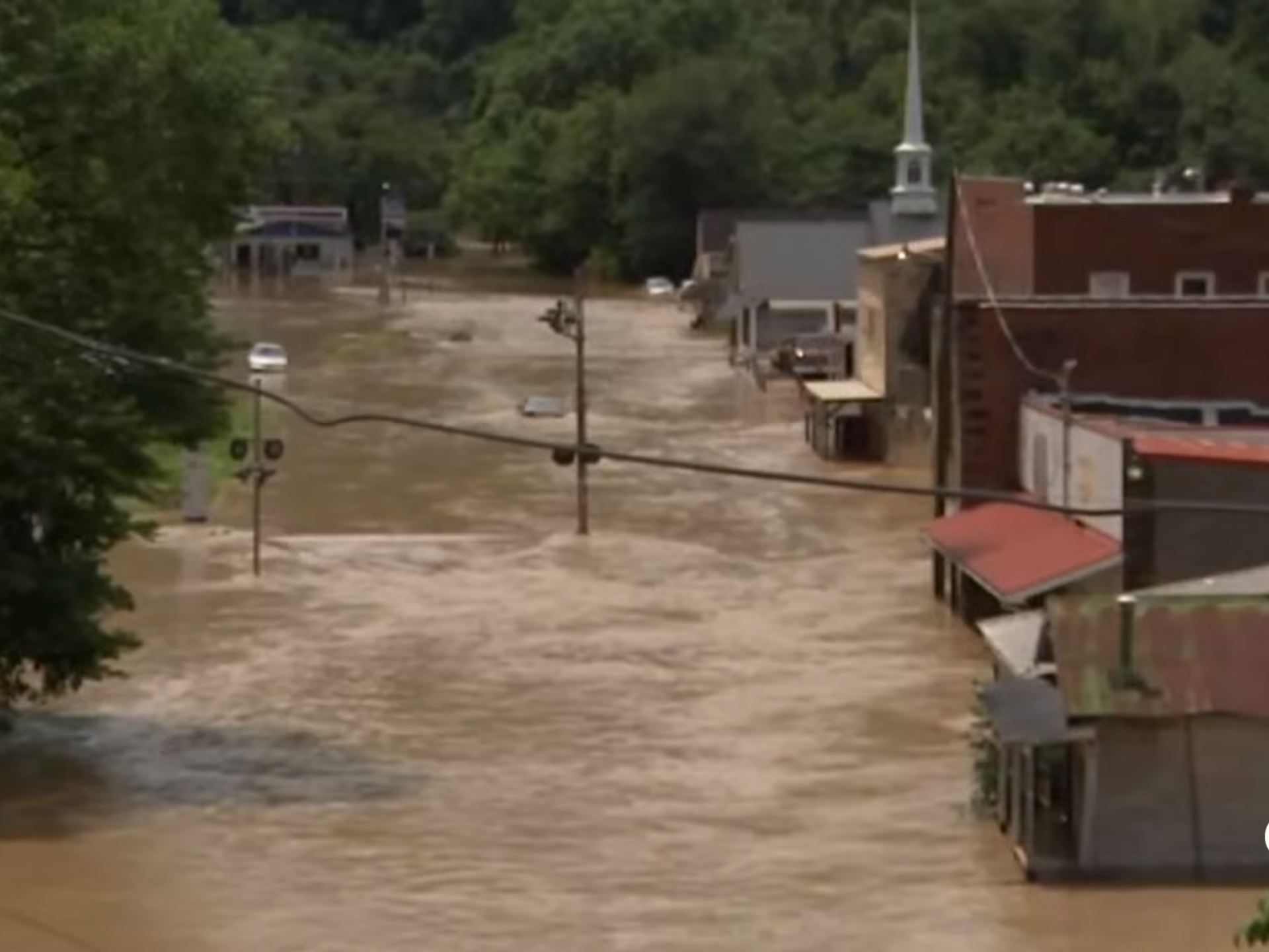
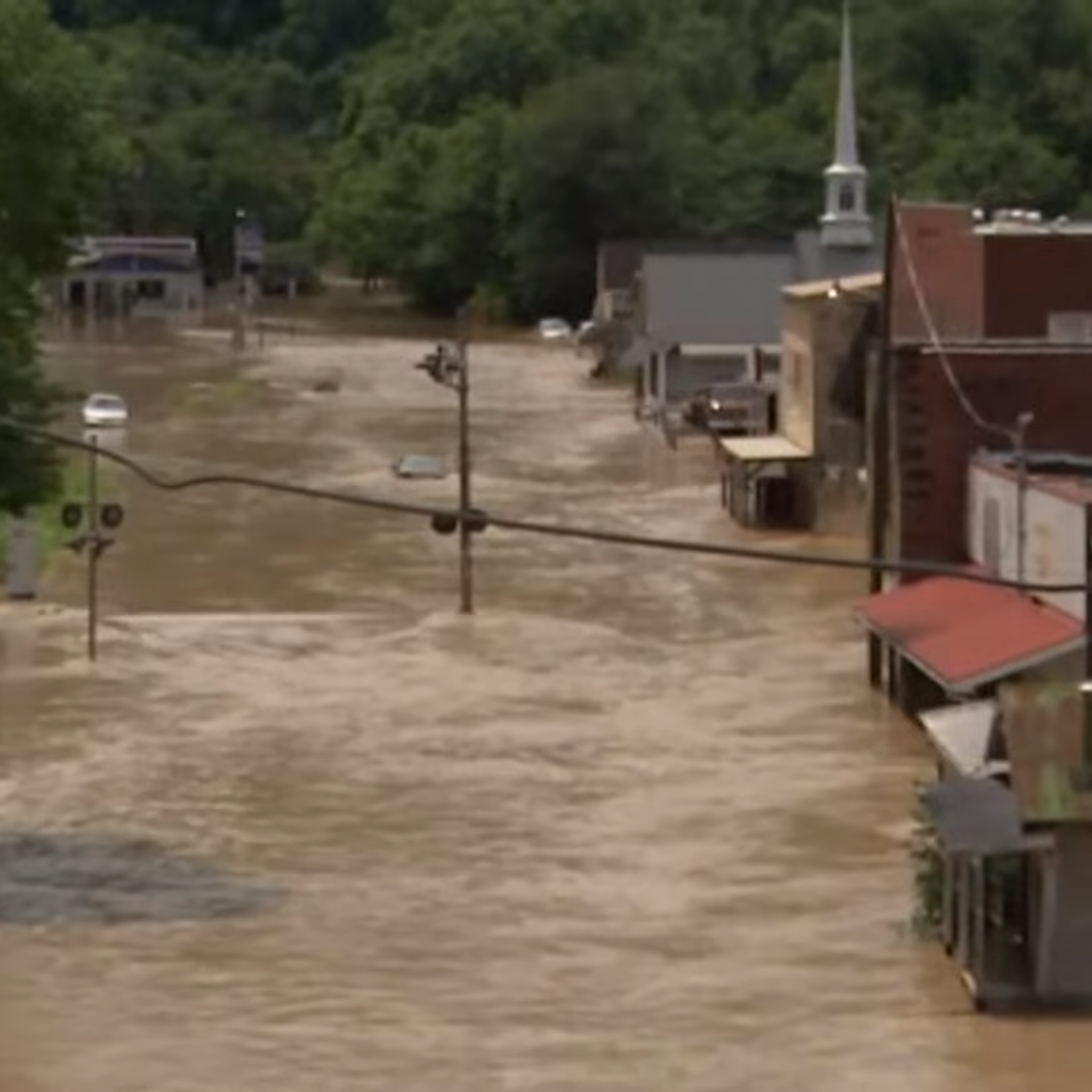
22:54 GMT 28.07.2022 (Updated: 08:49 GMT 14.02.2023) Towns in the Appalachian foothills of eastern Kentucky are reeling on Thursday after being inundated by catastrophic flooding from rivers swollen by drenching rains.
Torrential rains beginning on Wednesday caused streams and rivers to burst their banks, flooding towns across eastern Kentucky that are nestled in the region’s many valleys.
Kentucky Governor
Andy Beshear revealed on Thursday afternoon that the death toll had reached eight, although more dead are expected to be found in the coming days. He called the disaster “one of the worst, most devastating flooding events in Kentucky’s history.”
“I do believe it will end up being one of the most significant deadly floods that we have had in Kentucky in at least a very long time,” he said.
Some of the worst-hit counties include Breathitt, Floyd, Perry, Knott, Leslie, Pike and Magoffin, where between 11 and 14 inches of rain has fallen over the past two days. Videos and photos from the area showed valleys so full of water that only the tops of buildings could be seen. Buildings sat akilter on their foundations and cars and trees were twisted into unrecognizable shapes by the rushing waters.
“Our county has been devastated. We’ve just washed away,” Scott Sandlin of the Perry County Emergency Management Agency told the Washington Post. “It’s been the highest level of water I’ve ever seen.” The storms have also knocked out power to about 25,000 residents, and cell phone service is also gone in some areas.
National Weather Service meteorologist
Alex Lamers described the storms as an “extreme rainfall event,” noting that the amount of rain that had fallen was “more than double (!) the 1-in-100 average annual chance threshold, and a couple inches beyond even the 1-in-1000 threshold.”
The storms developed along the edge of a high-pressure
“heat dome” trapping intensely hot air over much of the United States - a dynamic driven by strong La Niña weather forces in the Pacific Ocean. Climatologists say that a
warming global climate is creating longer and more intense El Niño Southern Oscillations, the “cold” part of which is La Niña.
Globally, flooding has also become more intense, causing many such “1-in-100” year flooding events from
Maharashtra in India to
Sydney, Australia, and
KwaZulu-Natal in South Africa, which have claimed thousands of lives in recent months.
More rain is expected in Kentucky on Thursday night.


