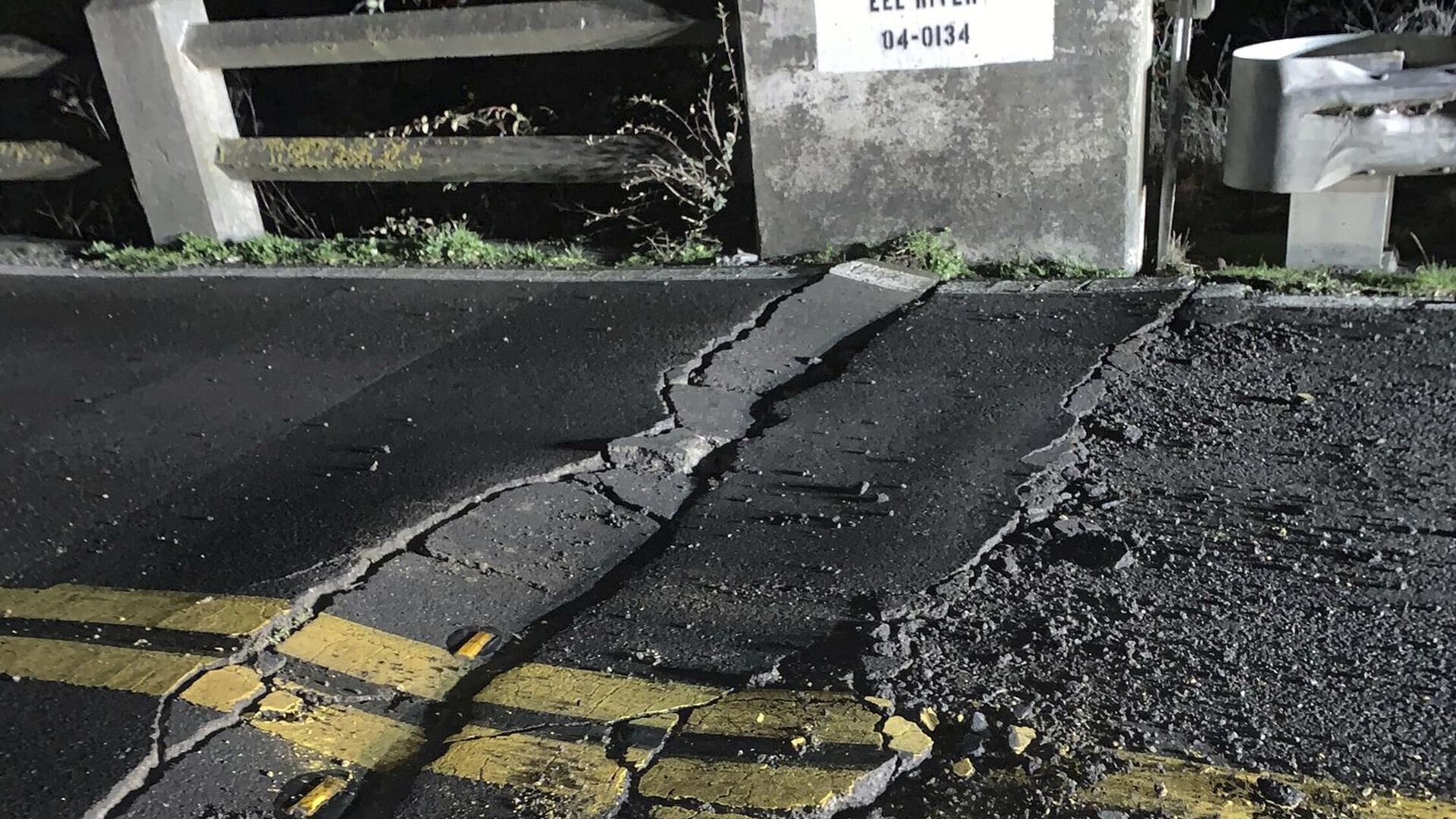
Roads Torn Up, Thousands Without Power After Northern California Shaken by 6.4-Magnitude Quake
16:37 GMT 20.12.2022 (Updated: 16:40 GMT 20.12.2022)

© AP Photo
Subscribe
The San Andreas fault, which runs the length of California, is said by seismologists to be “overdue” for a massive earthquake, which hasn’t happened in more than 160 years. The fault has suffered several strong earthquakes, but not the “big one” of magnitude 7.8 or higher, which would devastate the densely populated region.
At 2:34 am on Tuesday morning, a strong earthquake rocked northern California, destroying homes and tearing up roads and power lines, leaving nearly 100,000 people without electricity.
According to the US Geological Survey (USGS), the earthquake was magnitude 6.4 on the Richter scale and centered about 15 kilometers southwest of the city of Ferndale, just off the coast of the Pacific Ocean. It occurred at a depth of 17.9 kilometers.
A M6.4 earthquake has occurred south of Eureka, CA in northern CA (Humboldt Co.). Additional shaking from aftershocks is expected in the region. We are continuing to monitor this event, so check back for additional information. #Humboldt #earthquake pic.twitter.com/DpaIlz3RGV
— California Geological Survey (@CAGeoSurvey) December 20, 2022
At least two people were injured in the quake, according to local authorities.
The area is known to seismologists as the Mendocino triple junction, a place where the Pacific, North America, and Juan de Fuca plates meet. According to the USGS, the quake was the result of a strike-slip fault, or side-to-side action, and thus no tsunami warning was issued. Tsunamis are more commonly associated with thrust faults, in which the tectonic plate is shoved upward by another plate sliding underneath it.
California’s Humboldt County, that closest to the epicenter, suffered the greatest damage from the quake. According to utility tracking data, 71,000 of 99,000 power customers were without electricity at 6:30 am Pacific Time.
The Humboldt County Sheriff's Office warned of “widespread damages to roads and homes” on its Twitter account Tuesday morning. Fissures were seen stretching across roadways, and cracks were reported in the Fernbridge, which carries California Route 211 across the Eel River. The bridge has been closed by Caltrans for inspection.
Road Closure: State Route 211 at Fernbridge, Humboldt County is CLOSED. The bridge is closed while we conduct safety inspections due to possible seismic damage. pic.twitter.com/601oOQRz2o
— Caltrans District 1 (@CaltransDist1) December 20, 2022
Twitter users posted videos and photos of the damage to their homes.
“That was a big one,” a local journalist tweeted, with a video of an overturned china cabinet in her home. “House is a mess.”
That was a big one. Power is now out in #ferndaleca. House is a mess. #earthquake pic.twitter.com/YEmcv1Urhp
— Caroline Titus (@caroline95536) December 20, 2022
Sitting along a number of fault lines that form part of the Pacific Ring of Fire, California is the scene of regular earthquakes, most of which are minor, but which can also have extreme power. In 1906, a magnitude-7.9 quake destroyed 80% of San Francisco, killing more than 3,000 people. More recently, a magnitude-6.9 quake in 1989 centered near Loma Prieta Peak tore down highways, triggered a small tsunami, and halted a World Series baseball game happening nearby between two local teams.

