From Flooded Airport to Tectonic Fault: Satellite Images From Turkiye and Syria After Deadly Quake
From Flooded Airport to Tectonic Fault: Satellite Images From Turkiye and Syria After Deadly Quake
Sputnik International
A massive 7.7 magnitude earthquake followed by a second quake and hundreds of powerful aftershocks rattled parts of Turkiye and Syria on February 6, toppling thousands of homes and killing nearly 40,000 in both countries.
The power of the massive earthquakes that devastated parts of Turkiye and Syria last week equaled that of 500 nuclear bombs, and the 6 February earthquake became the most powerful to hit Turkiye since 1939.Aside from causing death and destruction, the earthquake caused flooding at the Turkish Hatay airport and triggered a geological shift that moved tectonic plates, as seen in satellite images.
A massive 7.7-magnitude earthquake followed by a second quake and hundreds of powerful aftershocks rattled parts of Turkiye and Syria on 6 February, toppling thousands of homes and killing nearly 40,000 in both countries. The death toll is expected to go up.
The power of the massive earthquakes that devastated parts of Turkiye and Syria last week equaled that of 500 nuclear bombs, and the 6 February earthquake became the most powerful to hit Turkiye since 1939.
Aside from causing death and destruction, the earthquake caused flooding at the Turkish Hatay airport and triggered a geological shift that moved tectonic plates, as seen in satellite images.
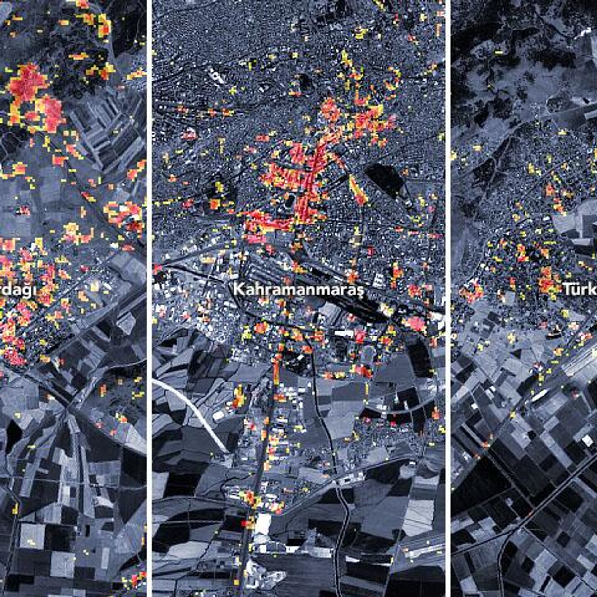
The preliminary damage proxy map above shows parts of the cities of Turkoglu, Kahramanmaras, and Nurdagi. Dark red pixels represent areas likely to have severe damage to buildings, homes, and infrastructure or changes to the landscape, whereas orange and yellow areas are moderately or partially damaged. Each pixel measures about 30 meters across (about the size of a baseball infield).
The Chinese Chaohu-1 satellite by Changsha-based Spacety Co Ltd also released satellite imagery of the earthquake zone. The radar remote sensing images show the surrounding area of the epicenter.
Damage proxy map of regions in Turkiye affected by the earthquake, including the cities of Turkoglu, Kahramanmaras, and Nurdagi. Dark red pixels show areas likely to have suffered severe damage to buildings, homes, and infrastructure or changes to the landscape, whereas orange and yellow areas are moderately or partially damaged. Each pixel measures about 30 meters across (about the size of a baseball infield).
Newsfeed
0
Access to the chat has been blocked for violating the rules .
You will be able to participate again through:∞.
If you do not agree with the blocking, please use the feedback form
The discussion is closed. You can participate in the discussion within 24 hours after the publication of the article.


.")


 and away (blue) from the satellite due to the earthquakes.")

.")

