https://sputnikglobe.com/20231018/archaeologists-aim-to-use-treasure-map-to-find-ancient-sites-across-northwestern-france-1114303500.html
Archaeologists Aim to Use ‘Treasure Map’ to Find Ancient Sites Across Northwestern France
Archaeologists Aim to Use ‘Treasure Map’ to Find Ancient Sites Across Northwestern France
Sputnik International
Archaeologists studying a mysterious stone fragment have made a startling discovery: the markings on the slab can be used to help them find other sites used by ancient humans, making it one of the oldest known maps of a territory.
2023-10-18T21:44+0000
2023-10-18T21:44+0000
2023-10-18T21:40+0000
beyond politics
brittany
france
bronze age
archaeology
https://cdn1.img.sputnikglobe.com/img/07e7/0a/12/1114303764_0:110:1583:1000_1920x0_80_0_0_ddf45051d4254f3989b8a655c1eeb45b.png
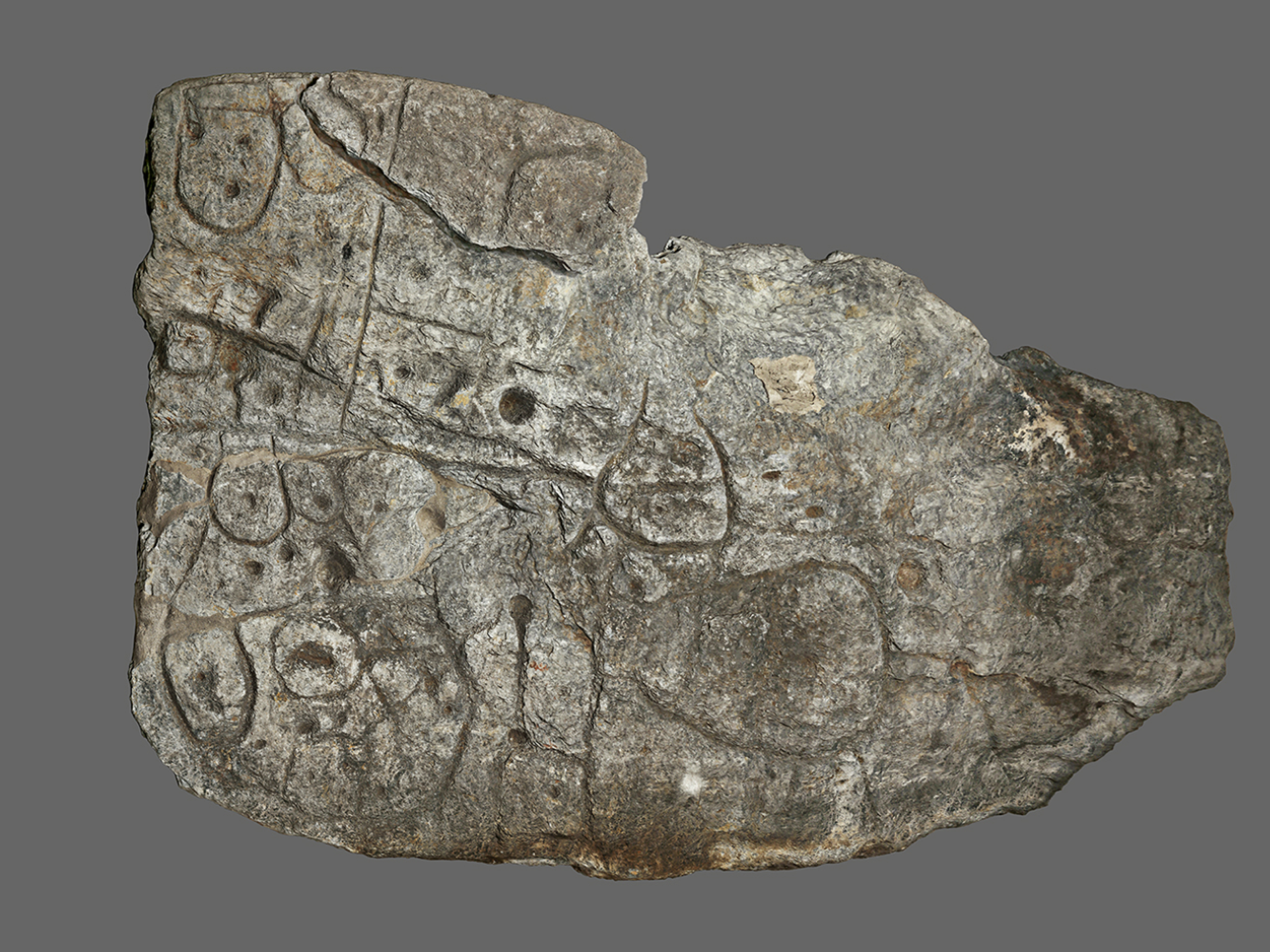
The Saint Belec slab was first found in 1900 in western Brittany in a prehistoric burial ground dated to be some 4,000 years old. However, the artifact was lost for over a century before being rediscovered in the cellar of a chateau in 2014, when serious study of its markings resumed.Since then, archaeologists have been working to decipher the slab’s markings, realizing they are likely a map."Using the map to try to find archaeological sites is a great approach. We never work like that," Yvan Pailler, a professor at the University of Western Brittany (UBO), told US media. "It's a treasure map.”The slab doesn’t have words on it, but the archaeologists realized the lines matched the contours of rivers and mountains in Brittany, France’s westernmost region, which is rich in megalithic sites made by prehistoric humans. Other markings include dots and pock marks, which might delineate burial sites or other locations of importance to the Bronze Age humans who made them.The slab is among the oldest known maps of a territory created by humans, dating to roughly 2,000 years before the Roman conquest of Gaul, or several hundred years after Stonehenge was built in England.
https://sputnikglobe.com/20230927/israeli-archaeologists-find-possible-first-known-grave-of-ancient-greek-courtesan-1113749681.html
brittany
france
Sputnik International
feedback@sputniknews.com
+74956456601
MIA „Rossiya Segodnya“
2023
News
en_EN
Sputnik International
feedback@sputniknews.com
+74956456601
MIA „Rossiya Segodnya“
Sputnik International
feedback@sputniknews.com
+74956456601
MIA „Rossiya Segodnya“
brittany; france; saint belec slab; bronze age; treasure map
brittany; france; saint belec slab; bronze age; treasure map
Archaeologists Aim to Use ‘Treasure Map’ to Find Ancient Sites Across Northwestern France
Archaeologists studying a mysterious stone fragment have made a startling discovery: the markings on the slab can be used to help them find other sites used by ancient humans, making it one of the oldest known maps of a territory.
The Saint Belec slab was first found in 1900 in western Brittany in a prehistoric burial ground dated to be some 4,000 years old. However, the artifact was lost for over a century before being rediscovered in the cellar of a chateau in 2014, when serious study of its markings resumed.
Since then, archaeologists have been working to decipher the slab’s markings, realizing they are likely a map.
"Using the map to try to find archaeological sites is a great approach. We never work like that," Yvan Pailler, a professor at the University of Western Brittany (UBO), told US media. "It's a treasure map.”
"There were a few engraved symbols that made sense right away," he added.

27 September 2023, 21:30 GMT
The slab doesn’t have words on it, but the archaeologists realized the lines matched the contours of rivers and mountains in Brittany, France’s westernmost region, which is rich in megalithic sites made by prehistoric humans. Other markings include dots and pock marks, which might delineate burial sites or other locations of importance to the Bronze Age humans who made them.
"We still have to identify all the geometric symbols, the legend that goes with them," said Clement Nicolas from France's Center for National Scientific Research (CNRS).
The slab is among the oldest known maps of a territory created by humans, dating to roughly 2,000 years before the Roman conquest of Gaul, or several hundred years after
Stonehenge was built in England.


